Gyro-stabilized multi-sensor electro-optical system
Defense and security
Gyro-stabilized platforms EVT-035A and EVT-035N
They are designed to equip fixed or rotary wing military aircraft, vessels and transport of all kinds, with the ability to acquire day and night images, also incorporating automatic tracking functions, on-board recording, laser rangefinder and geo target location.
These are hardened systems designed to operate in extreme environments, equipped with visible panoramic sensors and HD spotter, infrared sensor and laser rangefinder.
With the possibility of integrating into a dissemination system, the EVT-035A and EVT-035N platforms are essential tools for surveillance and monitoring for public safety, and search and rescue missions, among others.
EVT-035A and EVT-035N
General description
The EVT-035A and EVT-035N systems were developed and built by INVAP to meet the operational requirements of the Armed and Security Forces. The platform is designed to house multiple sensors or cameras and keep them stabilized against the movement of the aircraft, the vessel underway or the moving vehicle.
The cameras that equip the platform have been selected to fulfil the operational missions of surveillance, monitoring, search and rescue at sea, fire detection and night search.
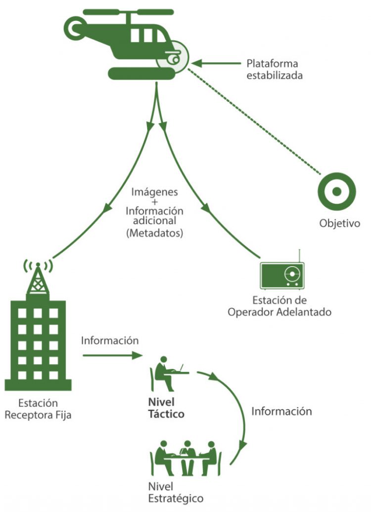
The Command and Presentation unit gives to the user the possibility to control the cameras and the platform to aim at the target, engage autotracking function, view the images and their associated data and control the on-board recording system. The combined data of the rangefinder, the GPS and the inertial unit of the system also allow estimating the georeferenced position of the target.
Optionally, the system can be integrated into a communications unit to transmit images to the ground through a secure digital link, where they can be received at an earth station, an advance operator unit or, if necessary, at both stations simultaneously.

Main features
Stabilized platform
- Stabilization: 5-10 microradians (5 active axes).
- Continuous 360° Pan.
- Travel elevation from + 30° to -120°.
Panoramic view camera
- 1920 x 1080 resolution.
- FoV 59.5 ° to 2.1 ° (optical) 30x optical zoom, 12x digital.
Visible spotter camera
- FoV 20 ° to 0.7 ° (optical) 30x optical zoom, 12x digital.
Infrared camera
- Spectral band: MWIR 3.6 to 4.9 micrometers.
- FoV 35.1 ° to 1.8 ° (optical) 20x optical zoom, 2x digital, 4x, 8x.
Autotracker
- With visible or infrared camera.
Image fusion
- Optional
10+ days of continuous recording
- On solid state disk
Encrypted Ground Transmission
- Optional
- Digital technology.
- Maximum range: 100km (5km with portable station).
Laser rangefinder
- Maximum range: 15km.
- Precision: 1m to 1km.
Laser illuminator
- Optical power: 1.8W.
- Bandwidth: 808nm.
